
A Word About Busan and the Events Surrounding Its Opening (1850-1876)
Prior to the city’s official naming in 1910, the area would have been referred to as being that of the Dongnae prefecture or the port of Fusan (the Japanese settlement).1 The Busan that we know today was originally a series of unconnected villages and towns that were later physically and politically unified. Largely due to its proximity to the Japanese archipelago, Busan had had a long history of contained communicative and commercial interaction with the Japanese, making it different from other cities on the Korean peninsula in that it was arguably already a marginally less isolationistic community. This was a result of it being the only point of contact between the Korean and Japanese governments.
It’s also important to note what was happening in other countries at this time. First, China was a kind of protectorate of Korea that the Joseon government would pay tribute to every once in awhile. Western imperial powers had been successful in establishing trade relations with China, yet almost all had been repeatedly turned down by the Korean and Japanese governments (the exception to this being a single Dutch trading post on the island of Dejima outside Nagasaki).
Demanding a trade agreement from the Tokugawa government, the fleet of an American commodore named Perry bombarded a few buildings in Ugara, Japan in 1853. Outgunned and intimidated, Japan signed an unequal treaty the following year that favored the Americans. This became one of the reasons for the Japanese government change in 1868. The Meiji period saw Japan rapidly reshaping itself to be an industrialized and “modern” society strongly influenced by the West. Eight years later, Imperial Japan adopted the same tactics that the Americans had used against them. Japanese gunboat diplomacy near Incheon brought about the forced signing of a treaty that gave Japan the same kinds of rights in Korea that the Americans got in Japan – including, perhaps most importantly, extraterritoriality. As a result, the port of Busan was opened to Japanese trade in 1876.2
Nampo-dong
Nampo-dong then became the site of the exclusive Japanese residential zone in Busan, an old concession designated specifically for Japanese citizens. It was originally an eighty-seven acre plot around Yongdusan that was established by the “Treaty on the Japanese Concession in Busan” in August of 1876.3 By December of 1880, Busan had become the home to about 300 Japanese settlers.4 Most of them worked in commerce, trade, retail, and entertainment. As the city was developed throughout the colonial period, the socio-economic center of Busan shifted from the magistrate in Dongnae to the Japanese concession in and around Nampo-dong. This shift in power revolved around wealthy Japanese merchants who had both the money and the ability to invest in the city’s infrastructure, which became more apparent as land reclamation (Jungang-dong, Sujeong-dong, Jwacheon-dong, Beomil-dong) and new town projects (Toeseong, Jungang, Choryang) developed over time.5
In the 1890s, English explorer and writer Savage-Landor described his first impression of Busan thusly:
I well remember how much I was struck when we entered the pretty harbour and approached the spot where we cast anchor, by the sight of hundreds of white spots moving slowly along the coast and on a road winding up a hill. As we drew nearer, the white spots became larger and assumed more and more the form of human beings. There was something so ghostly about that scene that it is still vividly impressed upon my mind.
There is at Fusan not only a Japanese settlement, but also a Chinese one. About two and a half miles distant round the bay, the native walled town and fort can be plainly seen, while in the distance one may distinguish the city and castle of Tong-nai, in which the Governor resides.6
Since the Japanese occupation, Nampo-dong has retained its legacy of being Busan’s trade center. While manufacturing later took place in land reclamation and new town areas, the Japanese concession was a merchant’s hub for commerce and trade. This is surely what English explorer Isabella Bird first saw when she stepped off the Higo Maru in 1895, for it was her opinion of Busan that:
It is not Korea but Japan which meets one on anchoring . . . It is a fairly good-looking Japanese town, somewhat packed between the hills and the sea, with wide streets of Japanese shops and various Anglo-Japanese buildings, among which the Consulate and a Bank are the most important. It has substantial retaining and sea walls, and draining, lighting, and roadmaking have been carried out at the expense of the municipality.7
The Japanese settlement in Nampo-dong therefore existed as a kind of microcosm in its early days, yet by 1903 it was already the home of around 5,633 Japanese citizens.8 This number dramatically increased to about 9,000 over the next year or two.9 During this time, Japanese influence increased as the colonists expanded into other parts of the city. It is then after the turn of the twentieth century that a certain duality within Busan became very apparent. This duality was defined by a growing socio-economic and spatial split between Koreans and Japanese. Though this split was visible at the time of the port’s opening, the Japanese settlement was rather contained during the first years of its establishment. Therefore, it was the eventual purchasing of land, rezoning of districts, land reclamation, and new town projects that essentially created the divide. This kind of infrastructure reshaping would become a defining characteristic of colonial cities throughout Korea. By the mid-1920s, the Japanese Empire had “spent more than thirteen million yen in providing modern facilities” to the city of Busan.10
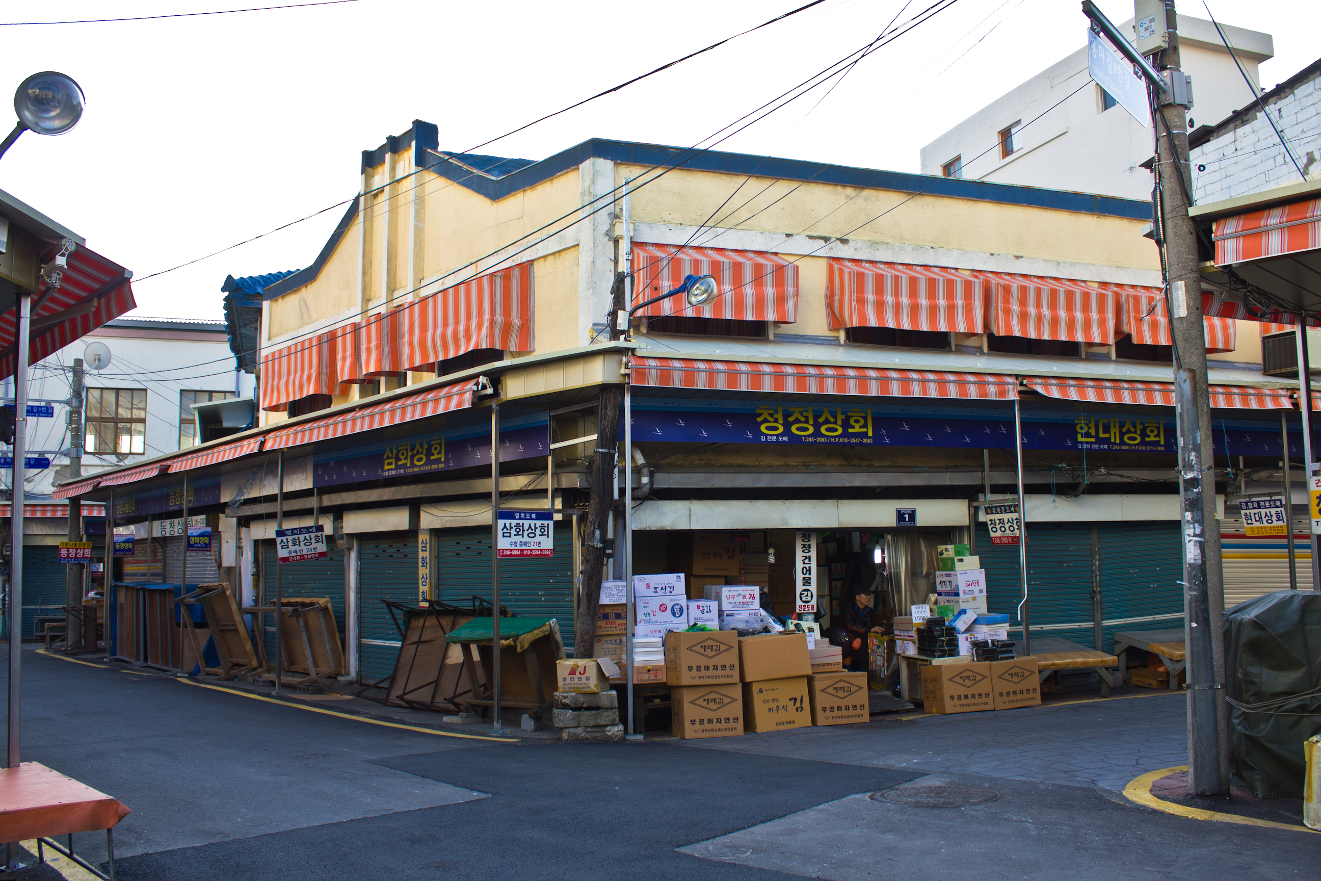
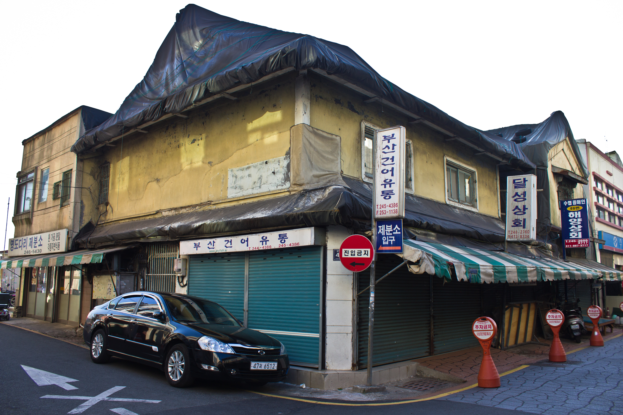
The architectural remains of colonial Nampo-dong lie in the dried fish market outside Nampo Station exits four and five. Starting with the two buildings pictured below, a number of these structures are in terrible disrepair. It is somewhat of a miracle that this area still exists at all, yet these structures offer a glimpse of what the place looked like at the time.
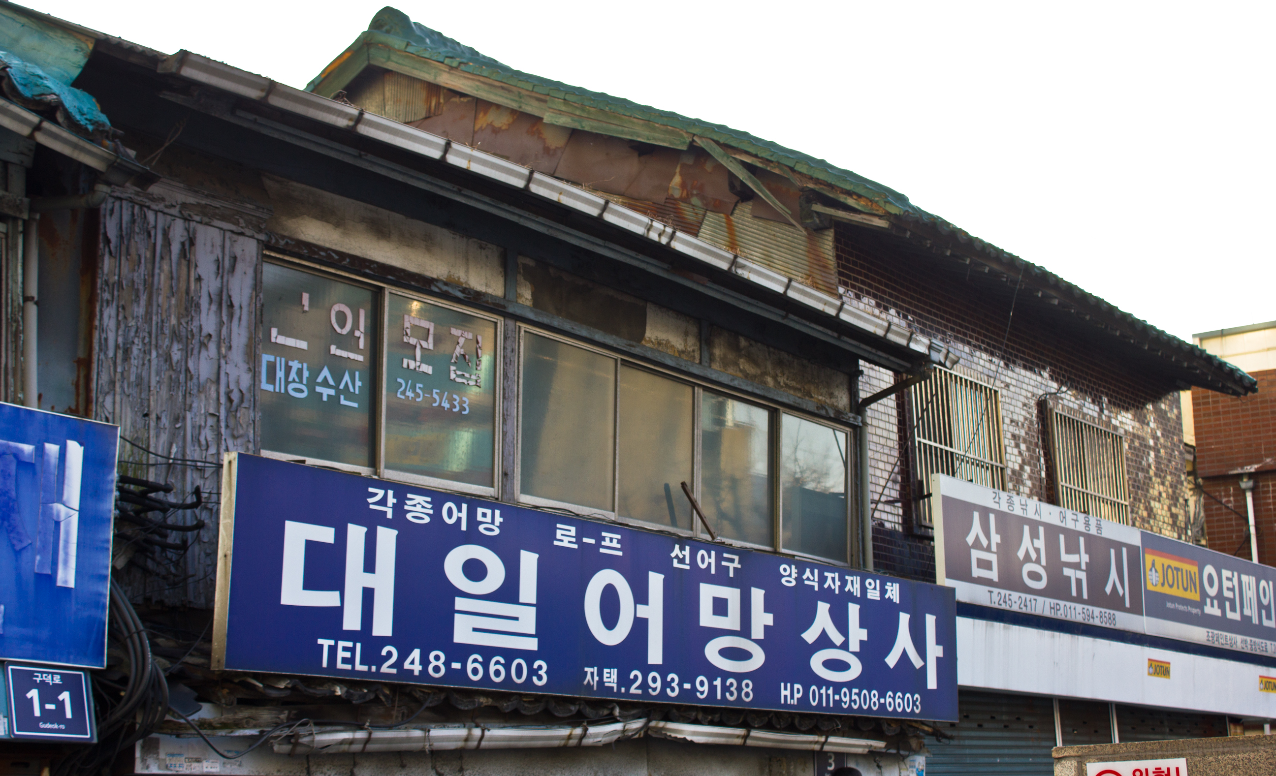
Once off the main street and inside the market proper, this section of Nampo-dong has a number of beautifully dilapidated buildings. Almost every structure here has had its first floor renovated beyond recognition as the market has seen nonstop use for over one hundred years now. That being said, the second stories of these structures clearly reveal their colonial and post-liberation origins. At least one seems to have been built with overlapping, horizontal wood siding – a style that may have been derived from Edo architecture because resembles designs from that period.

Another building was done with red bricks and framed in a Western style. The roof now covered to prevent leaking, it is typical of colonial era Japanese brick structures made to imitate “Anglo” architecture.
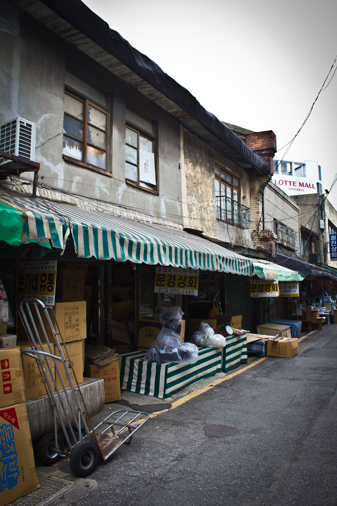

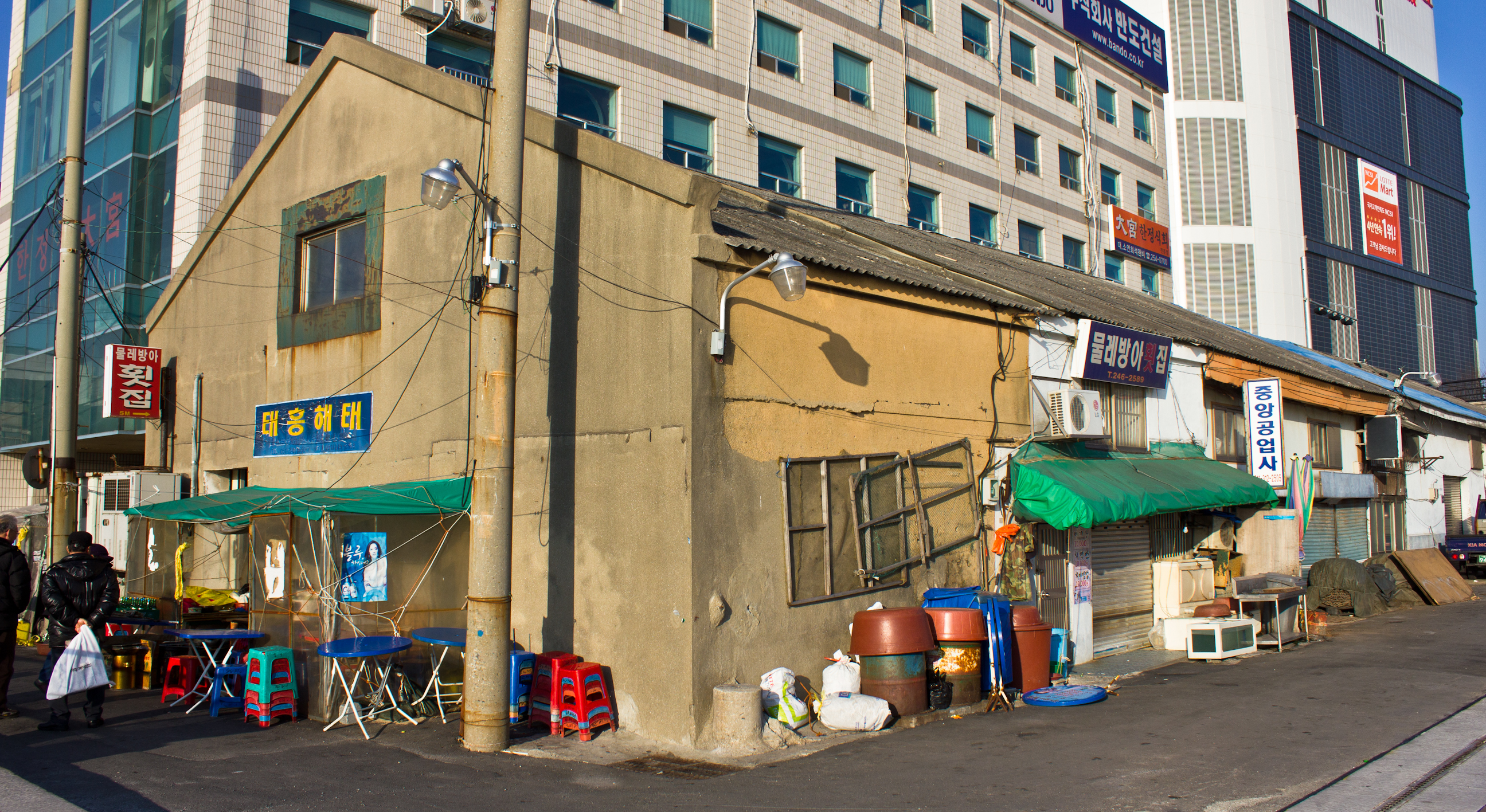
At an intersection, there is this run-down shanty. The frame is from the time of the Japanese occupation, but parts of the exterior have been patched up with corrugated tin. An old tiled roof is clearly visible beneath one of the tin sections. The row of store fronts continues down the street on the left.

At this same intersection is another long building with a gabled roof hidden by a possibly newer facade that could date to the 1950s. Taken at the beginning of this year (2015), this photo shows how all the sellers recently raised their canopies to a uniform height around the market, obscuring parts of the second floors of all these buildings.
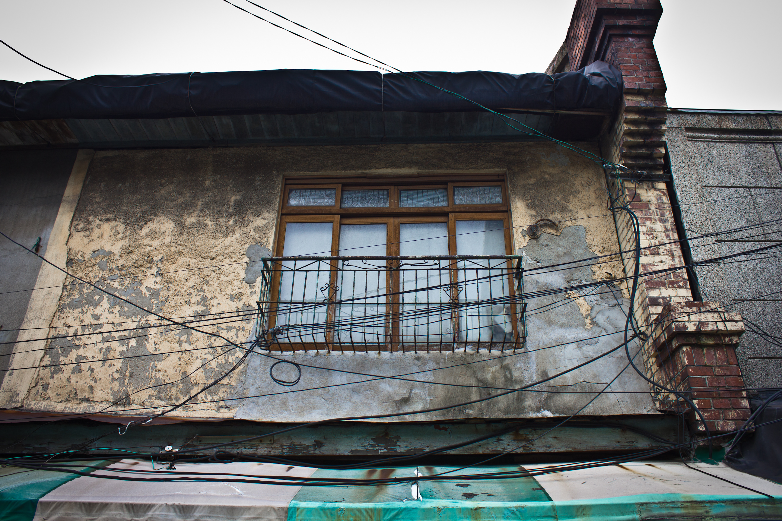
The most beautiful building in the dried fish market is this now pinkish-red Japanese house. Possibly dating to the 1930s, its circular art deco window gives the structure a lot of flair. Its roof is now covered with a vinyl tarp.


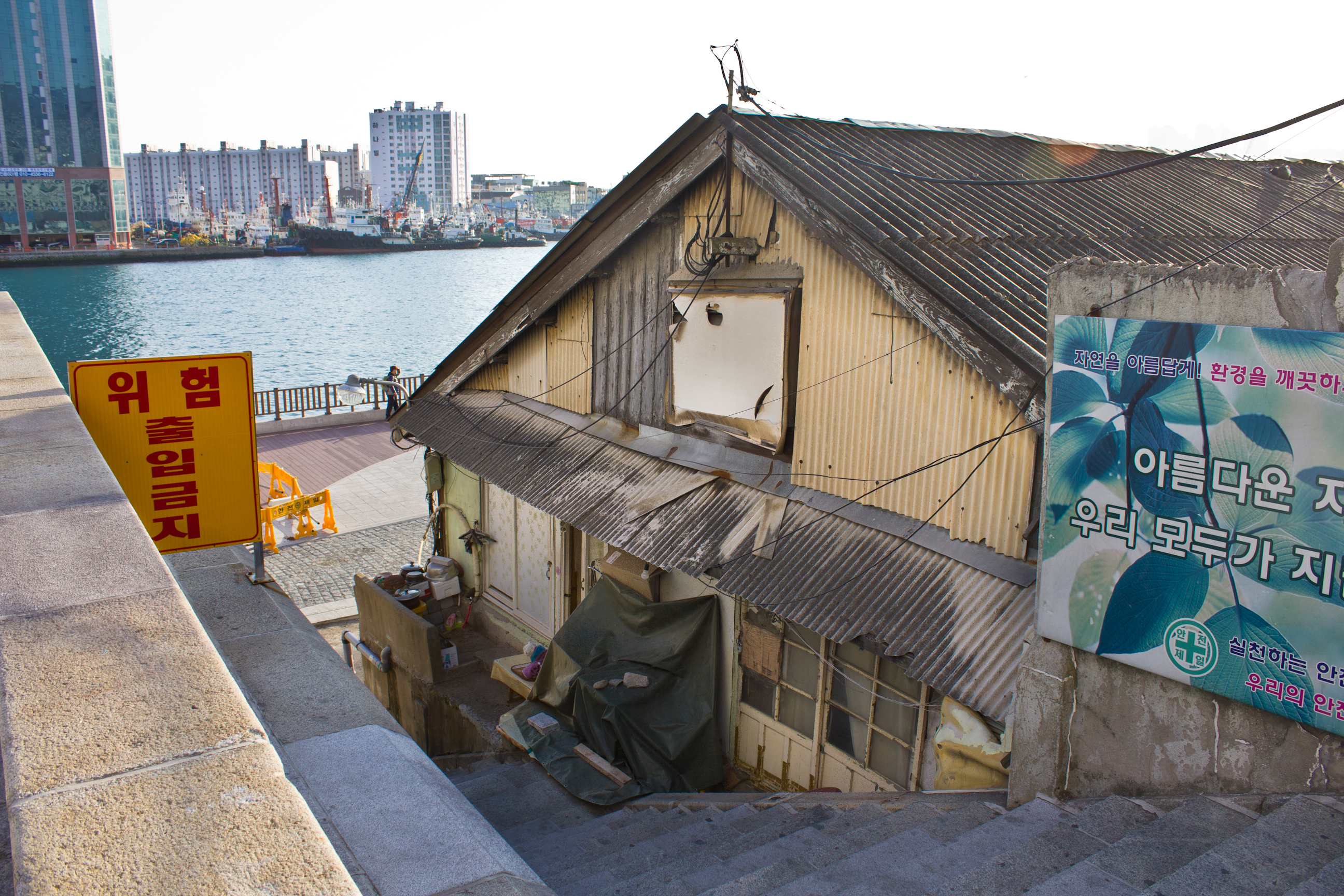
The street along the waterfront, and a street leading to it, retain a Japanese style home, an old warehouse, and another building whose exterior is now entirely made up of corrugated tin.

Update – May 19, 2016: Sections of this area have now been torn down, meaning some of the buildings pictured here may no longer exist. 😦
Footnotes
1 Oh Mi-il, “The Spatial Arrangement and Residential Space of a Colonial City: The Spatio-temporality of Hill Villages in Busan, ” Korea Journal 53, no. 1 (2013): 175.
2 An 1882 treaty between the United States and Korea later allowed for trade with other foreign nations.
3Hong Soon Kwon, “Formation of the Modern City of Busan: Focusing on the Space and Culture of the Japanese Settlement in Busan before 1910,” Korea Journal 48, no. 3 (2008): 3.
4Oh Mi-il, “The Spatial Arrangement and Residential Space of a Colonial City: The Spatio-temporality of Hill Villages in Busan, ” Korea Journal 53, no. 1 (2013): 182.
5 Oh Mi-il, “The Spatial Arrangement and Residential Space of a Colonial City: The Spatio-temporality of Hill Villages in Busan, ” Korea Journal 53, no. 1 (2013): 172-203.
6 A. Henry Savage Landor, Corea or Cho-sen: The Land of the Morning Calm (London: William Heinemann, 1895), 1-15.
7 Isabella Bird Bishop, Korea and her neighbors (Fleming H. Revell Company, 1897), 23.
8 Oh Mi-il, “The Spatial Arrangement and Residential Space of a Colonial City: The Spatio-temporality of Hill Villages in Busan, ” Korea Journal 53, no. 1 (2013): 179.
9 Oh Mi-il, “The Spatial Arrangement and Residential Space of a Colonial City: The Spatio-temporality of Hill Villages in Busan, ” Korea Journal 53, no. 1 (2013): 179.
10 Alleyne Ireland, The New Korea (New York: E.P. Dutton & Company, 1926), 19.
Building Locations
Dried fish market with old buildings in Nampo-dong:
Note: If you are visiting the dried fish market in Nampo-dong to take architectural photos, almost all of the photos in this essay were taken before the sellers raised their canopies to a point covering the second floors of these buildings. These canopies now obscure some of the cool parts of the structures.

Pingback: Busan (Part3) | Colonial Korea
Pingback: Busan (5) | Colonial Korea
Pingback: From the far side of Yeongdo Bridge - Synapticism