
Situated in the middle of Korea’s southern coastline, the micro-peninsula of Yeosu was heavily influenced by Japanese settlers and Western missionaries during the colonial period. Though the current city government of Yeosu likes to tout its Joseon legacy as related to Yi Sun-shin, this scenic getaway spot has a rich colonial history that deserves much more attention than it gets. The city has marked a couple of early modern historical sites – one of which was actually being “restored” when I visited. However, aside from some academic papers, little has been publicly said of the area’s colonial development – and a couple of spectacularly well preserved structures near the old harbor have received virtually no public attention at all.
Prior to the 1895 Gabo Reform, the present day micro-peninsula of Yeosu was known for containing Joseon’s Navy Command of Left Jeolla. It was also before this time that the Yeosu area fell under the administrative jurisdiction of its more important northern neighbor, Suncheon. The naval command was shut down in 1895, but rather than devolving into a poor little village, Yeosu’s harbor later grew as outsiders began to move into the area. It is important to note that while the county of Yeosu (Yeosu-gun) was merged with the county of Suncheon (Sucheon-gun) in 1897,1 the township of Yeosu (Yeosu-myeon) would have referred to the actual waterfront community that would eventually grow into a modern, urbanized port.
The Early Days
Today, the administrative jurisdiction of the city of Yeosu is rather spread out, covering most of the micro-peninsula. However, during the colonial period, Yeosu as a township only occupied a small coastal harbor around present day Jungang-dong. Modernity came to Yeosu much in the same way that it did in many small coastal fishing villages. Supported by Japan’s government, the settlement of Yeosu was officially subsidized in the same way that other migrant fishing villages were (Bangeojin, Guryongpo, Gampo, etc).2 Capitalizing on its coastal resources, Yeosu was transformed from a former Joseon naval command into a colonial economic center at the hands of migrant Japanese, enterprising Koreans, and a few pioneering Western missionaries. While we know it as Yeosu today, there were many who called it by its Japanese name, Reisui. (For the sake of clarity, I will refer to it as Yeosu throughout this essay. It was also previously romanized as Yosu).
The area’s wealth of marine resources, particularly sea bream, led to an influx of migrant Japanese fishermen. The early 1900s saw the establishment of some basic institutions, particularly postal and police agencies in 1906.3 Businesses continued to open up here and there as a sea route between Busan and Yeosu was established in 1908.4 Telephones made their way to Suncheon in 1909 and perhaps extended to Yeosu around the same time.5 Evidence of further infrastructure development can also be seen in the highway that was constructed between Yeosu and Suncheon in the following year.6
It is important to note that Yeosu shared significant social, economic, and administrative connections to the towns of Suncheon, Gwangju, and Mokpo. Not only did the Westerners come to Yeosu and Suncheon via Gwangju and Mokpo, but so did banks, businesses, and government entities. For example, in their early days, the postal service was supervised by Mokpo’s, the police agency was overseen by Gwangju’s, and when Yeosu’s customs was established in 1911, it was under the watch of the Mokpo customs house.7 While Yeosu was not quite a backwater town, it was dependent on its larger neighbors and may have still been viewed by locals as a satellite of Suncheon in the 1900s.
Throughout the 1910s, various banking systems (financial unions, agricultural or industrial banks, etc), fishing companies, factories, and institutional branches from other cities arrived in Yeosu. By 1912, a large migration of Japanese colonists had settled around Yeosu’s harbor.(migration article) This continued as, for example, a settler group from Hiroshima established a fishery in 1918.9
Development in the 1920s
As was the case in most modernizing Korean cities, the 1920s were significant in terms of urban development. By this decade, Yeosu’s population had grown to more than 6,000 with about 1,150 making up the foreign population.10 The Heungyang Fishing Corporation was established around the same time as Yeosu’s cholera outbreak of 1920.11 In 1921, a public school and clinic opened; and the following year, telephone lines were connected with Busan.12 Despite its twenty-some years of modernization, Yeosu did not get an official centralized port until 1923.13
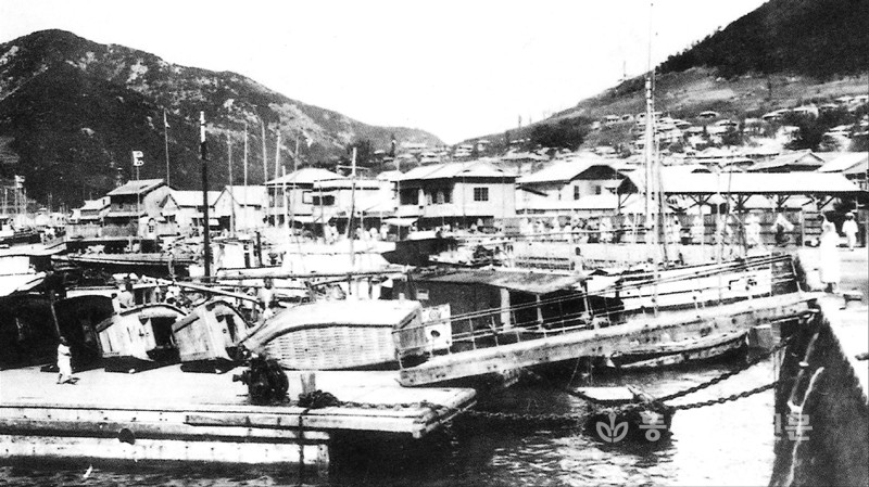
With a growing population, fishing unions were organized in 1924 and 1927. It’s also significant that in 1927, the Yeosu District Office was relocated to Gonghwa-dong,14 a neighborhood just half a kilometer north of the actual port where the water meets the land. Around this same time, ice production began specifically to aid the fishing industry in Yeosu. (Though I don’t have specific statistics for Yeosu, the Jeollanam province as a whole was reportedly already producing 7,428 tons of ice by 1931, peaking at 14, 598 tons in 1939 before decreasing again later).15 The financial sector continued to grow as, by 1928, the important Joseon Savings Bank opened its Yeosu branch.

Growth in the 1930s and 1940s
Further outside interest in Yeosu can be seen in the case of Kim Yeong-jun, an individual who had set up a rubber factory in Busan in 1929.16 Symbolic of a new class of wealthy, entrepreneurial Koreans that found success in the post-Joseon economic situation, Kim partnered with another man, Jeong Geun-mo,17 to create the Cheonil Rubber Factory in Yeosu, which was established in 1931.18 Indeed, Yeosu was an important rubber production center. By 1933, it was producing some 5,311 pairs of rubber shoes when in 1921 it had only made 171 pairs19 and the city would later have up to a couple hundred rubber factories.
The 1930s saw more growth in Yeosu following the opening of the rail line running between Gwangju and Yeosu in late December of 1930.20 It was also in this year that a sea route connected Yeosu with Shimonoseki, Japan.21 With direct connections to Japan established, Yeosu wouldn’t have been viewed as a little port village any longer. In April of 1931, it was promoted to the administrative level of a true town (Yeosu-eup). More banks continued to open. Schools, markets, a military police detachment, a youth center, the Joseon Migok’s warehouse, and a waste disposal service were all founded in the early 1930s.22 A report was issued in the late 1930s that documented the number of businesses in and around Yeosu at that time. There were 76 textile businesses, 153 related to metalwork and machinery, some 449 various breweries, 58 pharmacies or medicine related institutions, 52 in ceramics and copper work, 164 agricultural mills, 92 grocer or “goods” stores, 101 carpentry related businesses, 86 in printing, 112 in the chemical sector, and 201 rubber factories. 23 By 1940, Yeosu proper had a recorded population of 37,813 (up from the 1935 population of 28,205).24 Its coastal position also meant that it saw some visits from the Imperial Japanese Navy when cargo ships came and went during World War II.25


Land Reclamation: The Changing Shape of Yeosu’s Coast
As mentioned before, Yeosu did not get an official centralized port until 1923. Indicative of Yeosu’s new found importance, the port’s establishment helped foster future urban growth. Land reclamation projects were carried out for years during the 1920s. In 1920, an older section of the coastal area was connected to a newer section via reclamation.26 Another project was supported by the government in 1921 to create farmland for Goroe Farm, with more farmland being reclaimed two years later in 1923.27 Farmland for Goroe Farm was again reclaimed in 1925 as well as a small port section of the coast that was known as Jongpo28 (about half a kilometer east of the present day Yeosu ferry terminal). At the time, the waterfront may have been undeveloped enough to where Jongpo felt far enough away to be considered as separate from the main port, yet it is now part of the rest of the city. In 1927, Goroe Farm was corporatized.29

A section to the west of early modern Yeosu was reclaimed in 1928 (present day Guk-dong).30 Another coastal area used by a group of (probably local) divers was reclaimed in the same year.31 Sections of Jonghwa-dong and Jungang-dong were reclaimed in 192932 (with Jungang-dong getting a small brick lighthouse at some point in time). Across the bay, in or around present day Udu-ri (village), a coastal section was reclaimed in 1930.33 In 1935, Odongdo, a tiny island about one kilometer east of Yeosu’s port, received a breakwater between it and the mainland; and in 1936 the Sinhang area was reclaimed.34 Jonghwa-dong’s wharf was built in 1942.35


Jungang-dong, Gyo-dong, Gunja-dong, Dongsan-dong
Any review of Yeosu’s early modern architectural and historical remains must begin in Jungang-dong, for this is where the old Joseon naval command was established – and it is where the city’s modernization began. Before examining the buildings that were constructed during the Japanese occupation, let’s first have a look at the old Jinnamgwan, an impressive royal Joseon styled pavilion dating to 1718. It supposedly has the largest floor space of any wooden one-story building in Korea. Regardless of whether or not this is true, the structure is an impressive one. Though only the Jinnamgwan building remains today, the fortress area had eighty palatial structures and more than 2,000 private homes before being destroyed. The present Jinnamgwan (1718) structure was built over two other structures that burned before it.


The city government of Yeosu likes to promote this site a lot since Yi Sun-shin was headquartered here between 1593 and 1601. How is this related to Yeosu’s early modern history? The Jinnamgwan pavilion was converted into Yeosu Public School in 1911. After the 1910 annexation of Korea by Japan, it was common for old Joseon buildings to be repurposed after the Joseon political system ceased to exist. In the photo below from the 1930s, notice how the Jinnamgwan has Japanese styled sliding doors installed. This is just one example of the repurposing of Joseon buildings after annexation.

A few blocks south of Jinnamgwan sits the old Yeosu First Bank building. According to the Cultural Heritage Administration report, it was constructed sometime between 1939-1945. While I wasn’t able to access the inside, remaining sections of its interior crown moulding and second floor banisters have been documented (see the CHA’s official report by clicking here). It is a rather simple and plain concrete structure, though the interior would have originally been more decorative.


In Gyo-dong, off the present day shopping street of Jinnamsangga-gil, a curious red brick structure sits in the alleyway of Gyodongbuk-1 gil. The sign over the doorway reads 南都旅館 (Nanto Ryokan), which translates to Namdo Inn. With only one source online even mentioning the Namdo Inn,36 the history of this large three story structure will continue to be a mystery until someone with access to city records and university archives looks into it. However, I can offer my observations in the meantime. First, it is a blocky, three-story building that looks to have been made of reinforced concrete and finished with red brick. The layered lines of the string courses between each floor give the building a more moderne flair that is more apparent when viewed in isolation at the corners. While it is very tempting to say this is a 1940s structure, there is something about it that isn’t quite colonial. The flat roof is more in line with post-war buildings, as is its overall blocky style. This is more apparent when viewed from the rear. There is even something about the bricks that make it comparable to some 1960s red brick structures that I’ve come across. Further evidence of it’s post-war birthday is the built-in maintenance staircase on the building’s east side, which appears to be totally original and very reminiscent of industrialization era Korea. Red brick on facades also wasn’t very trendy by the 1930s and 1940s, particularly for businesses like hotels that would want to appear modern and in touch with the times. If the Namdo Inn is a late 1950s to early 1960s structure, it is one of few post-Korean War buildings like this left in the country.


Between the Jinnamgwan and the Namdo Inn are a few hillside homes and remaining brick walls.


A little east of the Namdo Inn is what one source has called the Im Hanyakbang,37 a traditional (Chinese) medicinal shop. It is a well preserved structure that deserves to be researched and protected given its architectural integrity. While I’m unsure of its construction date, I can offer my observations. If it was built with brick and finished with cement, it could date to as early as the 1910s. If it was built with concrete and its facade was finished with cement, a building with such construction probably wouldn’t have come to Yeosu until the 1930s. The architectural style is also more in line with post-1920 buildings found in Korea.


Next to the Im Hanyakbang sits an old water well. The Kanji/Hanja text inscribed on the stone wall indicates that the well was built by either a local youth group or business community (青友) in the year of the monkey (丙申), placing it in either November of 1896 or November of 1956. Now, 1896 is a little too early for this style of well. Additionally, a modern business community probably wouldn’t have existed yet in that year, much less a youth organization of any kind. The year 1956 seems a little too late for the construction of a water well in the downtown area of a developed urban area, especially when we consider that the Japanese brought in modern plumbing during the occupation. Then again, it’s always possible there was some unforeseen need for the well after the Korean War. The top character on the right stone is an obsolete one (sorry, I can’t type it out here – this character doesn’t exist on standard keyboards) usually used for peoples’ names and it is pronounced “Kyo”, possibly referring to the family name of a Korean (교) or the name of the group that built it. The water well only sits about 200 meters away from the actual waterfront and appears to still be getting some use.


On the hill a bit north, one can find the old Hanggyo (Confucian School). It’s been heavily reconstructed, but the Confucian hall was first built in 1897 along with two dormitories. It was expanded in 1934 to include a lecture hall (Myeongryundang), and in 1954 the lecture hall was expanded. Much of the timber work looks entirely too straight to be original, but I could be wrong. The stones and stairs are likely true to their respective periods, but I am skeptical of the site’s architectural authenticity.


We can see what looks to be another old well sitting next to the Hanggyo that has been covered over.

Nearby we can see an old hillside hanok with red brick and an interesting mid-century cement entryway to another home that is at the foot of the hillside hanok. However, the brick looks strange. It’s almost as if cement bricks were painted red – the color is really strange.


In Gwanmun-dong, we can find a rather boring building with a quite interesting history. The Yeosu Youth Association Hall was built during the colonial period by a social movement organization called “Matdophoe” which was made up of young men from Yeosu. The organization was first assembled in 1921 and was financially supported by a grain store and barber shop that its members operated. As a group, they promoted literacy and, interestingly, the burning of slave records. After the demolition of the post office near the Jinnamgwan, Matdophoe constructed this hall out of the left over materials and debris. It is a Registered Cultural Heritage site, mostly because of its anti-Japanese symbolism. The first floor is built of reinforced concrete with a traditional giwa roofed second floor. Sections of the eaves and roof look entirely too uniform to date to the colonial period, so the second floor may not be very original, but the concrete base certainly is. Notice the slightly decorative notches in the concrete entry posts at the base of the stairs, as well.


There are a few more old buildings nearby.


Near the water front in Jungang-dong on a small mountain sits Opodae Lighthouse, which was getting enveloped by urban sprawl until last year when some of its post-war and post-industrialization era neighbors were leveled to make way for a park. The colonial concrete and red brick lighthouse was “restored” in April and May last year by covering some of its exposed concrete bits and sealing its open window spaces with newer brick that attempted to match the original brick. The park officially opened at the end of May 2016.


In Dongsan-dong, the Bogwangsa temple can be found at the southern base of Chonggo-san (mountain). It sits in what would have been the edge of a highly developed area that spread from here to the train station (the area where the present day Yeosu Expo Center is). Judging by its location and the amount of wear and warping in the hanok-structure’s main wood supports, it may date to the colonial period.


North of the Expo Center is one of two colonial era tunnels dug through Miraesan mountain. Known simply as Mirae Tunnel 2, it was built at the same time as Tunnel 1 in 1926 and was intended as a military road. Tunnel 1 was for storage. Unfortunately, since it is a small one way road that is still in use, I didn’t dare walk inside to try to photograph the brick interior that I’ve seen in appearing in some photos. It looks like it may have been cemented over anyway. The outline of the original arch facade can be seen on close examination.


Yulchon-myeon
Sinpung-ri, a village within the township of Yulchon, contains one of the most peaceful and beautiful places I’ve encountered in Korea. The scent of pine intoxicates and vivid greens fill your field of vision at every turn. Hidden behind Yeosu’s airport, this secluded spot was once a leper colony established by Southern U.S. Presbyterians. The site stands as another example of how Yeosu’s neighbors played a significant role in this area’s development. But how did it get here?

In the 1900s, a Presbyterian presence was growing in Gwangju. It was here that R.M Wilson, a missionary doctor from the U.S., created a small hospital specifically for leprosy patients in April of 1911. Leprosy care was carried out in Korea before this time, but there may have been no dedicated leprosy facilities at all until 1910. (Note the first dedicated asylum may have been established in 1910 in Busan by Dr. C. H. Erwin and the British Leprosy Mission). Now, it is important to note a few things about Dr. Wilson’s medical philosophy. He believed that patients needed to remain active while being treated in order to foster positive thinking and to grant them autonomy in a world where they, lepers, had been rejected by society.38 In practice, this meant that they had farmland that the patients would work (in exchange for incentives like meat).39 This is more or less how Gwangju’s hospital for lepers continued to function until the 1920s.
As Presbyterian influence had spread to nearby Suncheon and the micro-peninsula that Yeosu sits on, so an attractive new piece of land became visible (present day Sinpung-ri). This secluded lowland area was, in the mind of Dr. Wilson, ideal for an isolated leper colony, and with the interest of an outside party, he soon made it a reality. Around 1924, one William Edward Biederwolf began evangelical campaigning in Asia. Hailing from the state of Indiana, Biederwolf took a particular interest in leprosy care in Korea; so much so that he supported, and was credited with, the establishment of Wilson’s new colony on the Yeosu peninsula. In 1926, the leprosy hospital in Gwangju officially began moving to this location and began a new life as the Biederwolf Leprosy Hospital with some 600 patients.40 Dr. Wilson designed the new location as a self-sufficient community, much in the same way he was previously doing in Gwangju but on a larger scale. The commune took about two years to be completed, though it would continue to expand and change over the years after. (Below is an example of the community’s currency, a one jeon note, from 1930.)
UPDATE: Per correspondence with Dr. Topple, Wilson’s vision may have been centered around land reclamation, which was carried out in order to create new farmland. In his words, “it took a few years for the salt leached out and allowed production but was worth it.” Financial contributions later came from student bodies of Presbyterian colleges in the American south, which is why small village areas in the colony had names after these groups, such as Davidson Village and Flora Macdonough Village.

The new colony’s church and hospital were constructed on a hill in the center of the colony with the patients’ quarters situated on either side of the hill – to the east and west of the main facilities. Today, many of the women’s cottages still remain, making it easy to see that they were constructed on the western side. The men’s cottages are now gone, but judging by past photos, it seems they were built on the little flat of land on the eastern side. There were also a number of smaller buildings, such as a rice mill, barn, etc. In keeping with Wilson’s vision, little work shops were constructed so that the colony could be virtually self-sufficient and manufacture anything that they might need.
 Biederwolf Leper Colony almost exclusively used stone in the construction of its facilities, which was quarried down the hill east of the hospital building. One of the reasons for this may have been its coastal position as stone can withstand the natural elements better than wood. Such stonework can also be found in the missionary structures of Suncheon and Gwangju, where the Presbyterians had a penchant for stone in the southern parts of Korea (stone was also a popular material in Jeju and Mokpo). However, it is important to note that the gray stone used in the buildings at the Biederwolf colony appear lighter in color than the buildings in Suncheon, suggesting that the stone was not sourced from the same site. The Presbyterian buildings in Suncheon use a darker granite that has more quartz, feldspar, or mica (the reflective granules found in granite). In Yeosu, the leper colony buildings seem to use a duller cut of granite. (Pictured below, the community worked to add stones around this new building’s wooden frame.)

At a cost of $500 USD per cottage (roughly $6800 each in present day money), seventeen men’s cottages were built at the time of the colony’s foundation. Uniformly constructed, each cottage had four rooms, a kitchen, and an attic. Twenty eight people were assigned to sleep in each one, likely not giving them much room or privacy. More of these men’s cottages may have been built later, yet, to reiterate, none of them seem to remain today. (Below is a photo of the men’s cottages from the period)

On the women’s side, there were initially fifteen cottages constructed. Notes on a missionary photo of a woman’s cottage suggest that seven more were built some time in the future. With only two rooms in each cottage, these were smaller than the men’s cottages and were built for $250 each. The women’s cottages all appear to have been constructed with uncut stone which were “laid in cement.” Today, the remaining women’s cottages have been cleverly transformed into little pensions (guest houses for rent, click here), and on close examination it appears that newer concrete was recently laid over the original cement. This was done in what is currently referred to as “wood grain stamping”, where wooden planks are laid against the concrete as it is drying to leave an imprint of the wood in the concrete. These cottages were renovated as guest houses sometime after 2000, and the trendy wood grain stamping seems to date to the time of the renovation.


Below is a photo showing one of the women’s cottages in the background and what appears to be Dr. Wilson on the left side of the frame.

All things considered, life at Wilson’s colony wasn’t bad, and those that lived and worked here most certainly had a higher quality of life than those at the Japanese operated leper colony on the nearby island of Sorokdo, a place that some have described as being a concentration camp.
The hospital building, which is now a museum, was built at the colony’s foundation around 1926. Only the exterior walls remain today as the interior has been gutted and renovated. The hospital used uniformly cut stone that was neatly laid in a typical brick fashion. In 1953, the building was expanded upon. It was used as the main hospital building until 1967 (the time when a new building was constructed, discussed further below). This building was converted into a museum in 1999.


The church building was also constructed around the time of the colony’s foundation. It used uncut stone and appears to have been a single room sanctuary. However, the original church structure does not remain today. It caught fire only a few years after its construction, around 1934, and a new one was built in 1935. This 1935 church building is the one that we see today. It, too, used uncut stone fitted together like a jigsaw puzzle, but in a departure from its predecessor, this church has a bell tower and features a vaguely Gothic faux-parapet on the roof. It was also around the time of the 1935 church building’s construction that the Biederwolf Leper Colony was given its new name, “Aeyangwon,” the name that is known by today in Korea. Westerners often continued to refer to it as the Wilson Leprosy Colony, even into the 1970s, and the Western Christian community would likely still use this name today. The hospital website still uses Wilson’s name to refer to itself in English.


A photo of the original church building constructed at the time of the colony’s foundation:

Wilson remained the director of Aeyangwon until 1940, a time when the (Japanese) Government-General cracked down on religious freedom by requiring residents in Korea to worship at Shinto shrines. This caused a number of issues for the Christian community and many refused to participate in Shinto activities. Around 1940, many, if not all, (and this is a point I’m unclear on) Western missionaries were deported out of Korea. Without more research, it is unclear how Aeyangwon was managed for the next five years after Wilson left. The next director, a Korean doctor named Son Yang-won, didn’t take directorship until 1945.
From 1948 to 1965, a missionary named Elmer Timothy Boyer, who had served in Korea since 1921, acted as director of the hospital. While the Kings Mountain Herald reported in 1954 that Boyer only planned to stay in Korea for one more six-year term, he remained as director of Aeyangwon until 1965.41 Dr. Stanley Topple arrived here in 1959 and succeeded Boyer as the director of Aeyangwon Hospital in 1965. Much of Topple’s work is well documented and, at the time, Aeyangwon began to attract polio patients in addition to those with leprosy. It was around 1967 under Topple’s directorship that a new, more modern hospital building was established nearby. Topple remained until 1981, after which a Korean doctor named Yu Gyeong-un (Yu Kyung Un) took over leadership until 1995. The current Yeosu Aeyangwon Hospital, a modern post-2000 building, sits about half a kilometer to the northwest of the original hospital.
Near the new hospital, the old Topple house stills remains today. While I need more research to confirm its construction date, it seems to have been built in the 1950s. The two-story building used square cut stones that, while not entirely uniform, were more uniform than the stonework of the 1935 church building. Behind it sits a single-story building of similar stone build whose original purpose I’m unsure of. The Topple house has since been renovated with a new roof, new windows, new porch, and new interior.
UPDATE: Per correspondence with the current director emeritus and Dr. Topple himself, the “Topple House” is an honorary title bestowed on this building, which was built in 1955. It served as a seminary for leper patients until 1962, at which point it was closed and repurposed into a prosthetic manufacturing facility. In 2000, it was converted into a guesthouse and dubbed the “Topple House”. When Dr. Topple arrived in 1959, the fencing and gate houses that formerly surrounded the place were torn down. Regarding the the 1940s, since the community largely governed and operated by itself, it is likely this is how it functioned even after the Westerners had to leave Korea around 1942.


Two more old stone buildings, whose original purpose I haven’t been able to discover, sit near the parking lot of the new hospital facilities.


Roughly eight kilometers northwest of Aeyangwon is the old Yulchon Station, a decommissioned train stop that once served the local community. When the Gwangju-Yeosu Line was completed in 1930, a private company called the Southern Joseon Railway used the line and constructed Yulchon Station around the same time (December 1930). The station is more or less in its original state, though the train tracks have been torn up as the station is no longer in use. It features a separated waiting room with the ticketing office in the center of the building. One section of the interior wall has been cut away and covered with glass to reveal the inner wall structure for visitors to view, though the station appears to remain locked almost every day. It underwent renovation/restoration sometime after 2014, resulting in its current appearance.


About half a kilometer away from the train station, still within Yulchon-myeon, sits Jangcheon Church. Another example of Christianity’s architectural legacy in Korea, this church is actually quite interesting despite its simple appearance. First, it’s elevated construction is relatively abnormal, and the entry steps lead up to the second floor. Secondly, its dual gabled porches house some interesting decorative woodwork. Though the original interior is no longer intact, it’s been speculated that it was very ornate. It now serves as a kinder/daycare run by the church. The newer building next to it was constructed in the 1970s, and the newest church is post-2000.


Dolsan-eup, Gunnae-ri

Dolsando, an island directly south of Yeosu proper, has a few more interesting historical sites that are rarely visited due to being a little less convenient to get to. The southwestern coast of Dolsando contains the old Bangdapjin shipyard. During the Joseon period, Bangdapjin was a naval base under the previously mentioned Left Jeolla Naval Command. The Honameupji from the 1870s noted that a force of eight warships and 705 soldiers were stationed at this base. However, this post dates as far back as 1522 and lasted until the Gabo Reforms in 1895. A military affairs office (Dolsan Gungwancheong) may have been constructed sometime around 1765, but the remaining office we today is thought to date to sometime after 1872 (pictured below). Built in a ㄷ shape, which is unusual for this part of the country, this office was done as a giwajip styled hanok. It mostly served as the Dolsan County Office after 1896, but it also took on the role of a police station and post office during the Japanese occupation.


Right next to the old military affairs office is a stone structure that still bears a “Yeosu Fire Station” sign at its entry. There’s even an old hand pump still inside the building. The interior seems to suggest it is being used a public space or community center now, but I haven’t been able to find any other information about it. Its style is in line with some of the Aeyangwon Hospital structures and could date to the colonial period but the roof eaves suggest it might be a 1950s or 1960s building.


Down the street are some remains of Bangdapjin Fortress, which can be found here and there as it was a 1,195 meter wall in circumference and about 3.9 meters high. A lot of the stones around here that have been reused may have come from the fortress walls.

When wandering the little streets around the village, old retaining walls, remaining mud-walled homes, and some giwa styled hanok can be found. There’s also an enclosed stele in a small giwa roofed pavilion.


Near the coastline, one arrives at the old Bangdapjin shipyard, which was only one part of the naval base here. It had an arsenal, a warehouse for goods, rice, water, uniforms, and a place to make weapons. The only parts that remain today are the shipyard (pictured below), which was used for the construction and repair of warships, and the gulgang, which are deep bays that allowed for easy deployment and protection of ships (unpictured). I visited the old shipyard at low tide, which shows how shallow it is.


To see the entire Flickr gallery, click here.
Footnotes
1문영주, “식민지기 전통도시 순천의 근대화 과정과 지역민의 대응,” 韓國史學報 제42호 (February 2011): 204.
2Chung-Shin Park and Tai-Young Kim, “Formation and Transformation of Japanese Migrant Fishing Village Colonies in Korea,” Journal of Asian Architecture and Building Engineering 10, no. 2 (2011): 291.
3똑소리, 2016.
4똑소리, 2016.
5똑소리, 2016.
6똑소리, 2016.
7똑소리, 2016.
8Chung-Shin Park and Tai-Young Kim, “Formation and Transformation of Japanese Migrant Fishing Village Colonies in Korea,” Journal of Asian Architecture and Building Engineering 10, no. 2 (2011): 291.
9똑소리, 2016.
10Chung-Shin Park and Tai-Young Kim, “Formation and Transformation of Japanese Migrant Fishing Village Colonies in Korea,” Journal of Asian Architecture and Building Engineering 10, no. 2 (2011): 291.
11똑소리, 2016.
12똑소리, 2016.
13똑소리, 2016.
14똑소리, 2016.
15최재성, “1930년대 여수지역의 공업화와 그 전후(前後)의 변화,” 大東文化硏究 Vol 67 (2009): 149.
16최재성, “1930년대 여수지역의 공업화와 그 전후(前後)의 변화,” 大東文化硏究 Vol 67 (2009): 140.
17최재성, “1930년대 여수지역의 공업화와 그 전후(前後)의 변화,” 大東文化硏究 Vol 67 (2009): 141.
18최재성, “1930년대 여수지역의 공업화와 그 전후(前後)의 변화,” 大東文化硏究 Vol 67 (2009): 141.
19최재성, “1930년대 여수지역의 공업화와 그 전후(前後)의 변화,” 大東文化硏究 Vol 67 (2009): 141.
20최재성, “1930년대 여수지역의 공업화와 그 전후(前後)의 변화,” 大東文化硏究 Vol 67 (2009): 150.
21똑소리, 2016.
22똑소리, 2016.
23최재성, “1930년대 여수지역의 공업화와 그 전후(前後)의 변화,” 大東文化硏究 Vol 67 (2009): 132.
24최재성, “1930년대 여수지역의 공업화와 그 전후(前後)의 변화,” 大東文化硏究 Vol 67 (2009): 154.
25 Donald A. Bertke, Don Kindell, and Gordon Smith, World War II Sea War (Dayton, OH: Bertke Publications, 2009), 354.
26똑소리, 2016.
27똑소리, 2016.
28똑소리, 2016.
29권역별안내 고뢰농장, 여수관광문화 (2015).
30똑소리, 2016.
31똑소리, 2016.
32똑소리, 2016.
33똑소리, 2016.
34똑소리, 2016.
35똑소리, 2016.
36똑소리, 2016.
37똑소리, 2016.
38 Lee, Hong Yung, Yong Chool Ha, and Clark W. Sorensen. Colonial Rule and Social Change in Korea, 1910-1945 (Seattle, WA: University of Washington Press, 2013), 253.
39 Lee, Hong Yung, Yong Chool Ha, and Clark W. Sorensen. Colonial Rule and Social Change in Korea, 1910-1945 (Seattle, WA: University of Washington Press, 2013), 253.
40 연혁, Wilson Leprosy Center and Rehabilitation Center Website (2012).
41 “Missionary To Speak Here,” The Kings Mountain Herald (August 19, 1954).
*Note: All the older photos used above of Aeyangwon, such as the one jeon currency note and the photos of the old church and women’s cottages, are on display at the museum there. These all appear to be copies or scans of photos that the missionary doctors took during their time there.
Building Locations

This whole post is incredibly detailed and so fascinating. The pictures and descriptions remind me so much of my own time in Korea. Thank you so much for the work it took to post this.
LikeLike
Thanks, Logan!
LikeLike
Pingback: Bookmarking: Korean architecture | thesememorieswhich